Haitian cuisine is truly special. Its dishes are spicier than most other Antillean cuisine’s. Besides the strong African influence – there’s also French, Arabic and Amerindian – and every manman has her own secrets, inherited from ancient times and refined over generations!
 Gathering lunch
Vegetables on Hispaniola are extremely tasty – and part of any dish. Furthermore, meals are based on seafood & fish, meats as goat (cabrit) and pork (griot), but also chicken and beef. Rice, with or without beans, accompanies every meal. It’s called “nourriture” – a meal without rice is not considered to be a meal.
Meat is usually cleaned and marinated in bitter orange juice, fish in lime juice.
To meals one can drink beer or fruitjuice.
STARTERS
ACCRAS DE MORUE – codfish pasties
The name accra is said to come from “akara”, which means “pasty” in Éwé, a Mandinga-language spoken in Ghana.
Codfish pasties are a typical dish made up of potatoes, bacalhau (codfish), eggs, parsley, and some other minor ingredients. The bolinhos or pastéis de bacalhau – as called on the Portuguese coast and in Brasil, where they are very popular as well- are deep fried and served before meals or as a meal itself (usually served with rice).

- 300g dry codfish, desalted for at least 1h.
- 300g potatoes, previously boiled in saltwater
- 1 egg, beaten
- black pepper, garlic
- optionally: clove, thyme, parsley, chilli, 1 tbsp. of vinegar
- breadcrumbs or “pannade”
Desalt the codfish in water, drain it, clean bones off, shred and mash it together with the potatoes. Mash with beaten egg, garlic, pepper. Shape into small balls and roll in breadcrumbs. Fry in hot oil.
You can use flour instead of potatoes, in this case add a cupfull of water and some baking powder.
Serve with raw vegetables as starter.
COD CHIQUETAILLE
The word ‘chiquetaille’ means ‘shredded’. As refrigeration is still scarce on the island, fish is often salted for conservation reasons.
 ©cookinginsens.wordpress.com
The fresh version
- 200 g salt cod fillet
- some flat leaf parsley and thyme
- 2 – 3 chives (or green onions)
- 1 onion, minced
- 3 cloves of garlic
- 1 lime
- chili to taste
- salt and pepper
- oil
Soak the cod in cold water for 15 minutes to rehydrate it and remove the salt; fillet it, removing the bones if necessary; flake the meat with your fingers.
Finely chop the onion, garlic, chives, herbs and chili; blend into the cod;
drizzle with lime juice and oil.
Serve it with baguette; alternatively in an avocado half or with lettuce-tomato salad. Or, like in the pic, with some green beans and carrot.
The time-costly method, more adequate for conservation
- 450g salted cod
- 1 large onion, finely chopped
- 2 large shallots, finely chopped
- 5 large cloves of garlic, finely chopped
- 2 carrots, very thinly sliced
- 1 1/2 cups of young green beans, cut in half, vertically
- 1/2 green bell pepper, thinly sliced
- 1/2 yellow or red bell pepper, thinly sliced
- 1 green jalapeno with seeds or 2 scotch bonnets, thinly sliced
- 1/2 cup vinegar
- 1 cup olive oil
- 3 or 4 whole cloves
- Salt and pepper
Soak the cod in cold water in the refrigerator for 24 hours, changing the water 3 times. In a large pot, bring to boil enough water to cover the fish and boil for about 20 minutes. Drain in a vegetable strainer and when cool, remove skin, bones and any unsightly fish parts. Shred by hand.
Mix the shredded fish with the vegetables, olive oil, cloves, salt, pepper and vinegar. Refrigerate for at least 4 days. Serve spread on baguette slices for cocktails or as a salad with lettuce, tomatoes and hard boiled eggs.
SOUPE JOUMOU – pumpkin soup, the national dish
Slaves were not allowed to eat this nourishing soup. On the 1st of January 1804, they cooked soup Joumou (from “Giraumont” – a pumpkin type) for the first time. It became the national dish. It is served on National Day, Sundays and special occasions.
 ©kreyolcuisine.com
- 500g cubed beef stew meat
- 500g beef shank or chicken
- 250g smoked lard
- 1 ½ cups rigatoni
- 1 giraumon pumpkin, peeled and cut (or 1kg frozen)
- 1 turnip, diced
- 1 small cabbage, leafed
- 3 large potatoes, diced
- 1 celery stalk, coarsely chopped
- 1-2 onions, sliced
- 4 cups beef broth
- 3 carrots, sliced
- 1 leek, cut
- 2 cloves
- Salt, pepper, to taste
- 1 tablespoon white vinegar
- 1 tablespoon olive oil
- Cayenne pepper, to taste
- 1-3 limes
- 1 tablespoon butter
Wash meat with lime and water. In a large saucepan, boil the shanks and beef and lard cubes until each piece is tender. Add the giraumon. When the giraumon is cooked, puree and return to pot.
Add vegetables, pepper, salt, cayenne to taste, cloves and rigatoni. Pour the beef broth by covering everything. Bake until rigatoni and vegetables or tender.
Add oil, vinegar and butter. Simmer 20 minutes over medium heat.
Serve with baguette.
SEAFOOD
LAMBÌ BOUCANNÉ – Buccanneered conch

- 1 lambì
- lime, salt, hot chili sauce
Lambì is a conch that seems very hard to find outside the Caribbean space. Nevertheless, should you find one – clean it first: remove the ‘lid’, then the intestine; wash in plenty of water, until not sticky anymore. Clean all dark spots and hard parts away with a knife. Rinse again with bitter orange juice (or sea-water, if nothing else around). Then just place it over a fire until it gets cooked. Season with lime and chili sauce (e.g. tabasco).
Can be served plain – or with rice or plantain.
Alternative: cooked lambì

Same ingredients as before, same preparations required. This lambì was cut to threads, then cooked and seasoned with salt, lime and hot chili sauce.
BUCCANEERED LOBSTER
 Oma boukannen ak banann peze – Buccaneered lobster with plantain
- 1 lobster
- salt, garlic, lime
Cut along the spine, grill. Add lime and garlic if desired, serve with fried plantain – banann pese (see below) or white rice.
POISSON GROS SEL

- 4 pink fish, i.e. red snapper or sea bream
- 1 lime
- 1 tablespoon tomato paste
- salt and pepper to taste
- hot pepper to taste
- 4 cloves
- juice of one lime
- 2 cloves garlic
- 2 shallots
- 3 tablespoons olive oil
- 1 onion
- 2 peeled tomatoes, chopped
- 1/2 teaspoon thyme
- 1 tablespoon chopped fresh parsley
- 1 cup water
Clean, shell fish and remove the bones and entrails. Rinse with cold water and rub with lime. Prepare the marinade by placing mashing shallots, cloves, pepper, lime juice, minced garlic, salt and pepper in a bowl.
Make incisions in the fish to rub the marinade and let marinate for at least 3 hours.
Heat oil in a deep skillet, add onion, minced garlic, tomatoes, tomato paste, thyme and parsley. Sautéd well. Add the remaining marinade, followed by water and bring to a boil. Add fish and simmer 20 minutes over medium heat.
Serve with rice and beans (see below) or plantains.
POISSON ROSE – Red snapper

- 4 pink fish, i.e. red snapper or sea bream
- 1 lime
- 1 tablespoon tomato paste
- salt and pepper to taste
- hot pepper to taste
- 4 cloves
- juice of one lime
- 2 cloves garlic
- 2 shallots
- 3 tablespoons olive oil
- 1 onion
- 2 peeled tomatoes, chopped
- 1/2 teaspoon thyme
- 1 tablespoon chopped fresh parsley
- 1 cup water
Clean, shell fishes and remove the bones and entrails. Rinse with cold water and rub with lime.
Prepare the marinade by placing the following ingredients in a salad bowl: shallots, cloves, pepper, lime juice, minced garlic, salt and pepper. Mash everything together.
Make incisions in the fish to rub the marinade and let marinate for at least 3 hours.
Heat oil in a deep skillet, add onion, minced garlic, tomatoes, tomato paste, thyme and parsley. Sautéd well. Add the remaining marinade, followed by water and bring to a boil. Add fish and simmer 20 minutes over medium heat.
Serve with fries or Diri kolé ak pwa (see below) or boiled green plantains.
MEAT
GRIOT – fried pork
 ©kreyolcuisine.com
- 2 kg boneless pork, cut into pieces
- 1 cup chopped onions
- 1 cup lime juice
- ½ cup sour orange juice
- 1 tablespoon vinegar
- 2 cloves garlic, finely chopped
- 1 coarsely cut green pepper
- 2 teaspoons chopped parsley
- 3 finely chopped shallots
- 4 cloves
- ½ teaspoon salt
- ½ teaspoon black pepper
- ½ cup oil, for frying
Rub the pork in lime juice. Rinse with warm water.
Combine remaining ingredients, except for oil and orange juice. Let the the pork soak in this mixture and marinate in the refrigerator (4 to 24 h).
Place in large saucepan over medium heat and add the orange juice. Cover and cook for 30 minutes.
Remove the meat, drain. Fry the pork in hot oil, turning the pieces occasionally, until they are crisp.
Serve with pickliz and fried plantain.
TASSO – fried cubed beef/goat

- 1 kg steak or goat cut into small cubes
- 1/2 cup of chopped shallots
- 1/2 cup of orange juice
- 1/4 cup lime or lemon juice
- 1/2 cup of vegetable oil
- salt, pepper to taste
- 1 tsp of parsley
Put all ingredients except the oil in a large pot and marinate at least 4 hours.
Transfer meat mixture to medium saucepan or pressure cooker and add water to cover.
Heat to boiling and reduce heat. Simmer covered until meat is very tender.
Fry meat in a large pan until crisp and golden brown.
HAITIAN STYLE CHICKEN
 Mme Jesula preparing for a grand dinner
- 1 chicken
- garlic, salt, pepper
- oil
- 1 onion
- 1 bunch parsley
- 12 cloves
- 2 tbsp. tomato paste
Cut the chicken into pieces, wash, season with the marinade made with garlic, salt, chopped pepper. Sauté the chicken in some oil, cover and cook for ca. 30 minutes on medium-high. Drizzle with water, so the meat won’t stick to the pan. When tender, lower heat a bit and add the chopped onion, parsley, cloves, tomato paste, dilluted in the marinade. Let simmer for a few more minutes and serve hot with rice and beans (diri kolé ak pwa, see below)
MARINADE for chicken, pork or beef
- 1 cup corn oil
- Juice of 1 lime
- 1 tablespoon chilli powder
- 1 laurel leaf
- 1 sprig of fresh parsley, chopped
- 1 teaspoon Cayenne pepper
- 1 mashed garlic
- 1 thym
- 4 cloves
- 2 shallots
- 1 minced onion
- Salt and pepper to taste
Mix all ingredients together. Brush over meat and let marinate for 2 hours or more in the refrigerator.
Use only as much as needed for marinating, keep a certain amount to use during cooking.
KALALOU (OKRA) WITH BEEF
 ©kreyolcuisine.com
- 500g okra (kalalou)
- 450 g beef, cubes
- 1 large chopped onion
- 3 finely cut shallots
- 2 cloves of garlic
- salt, to taste
- 2 cups water
- 1 tablespoon vinegar
- ½ cup oil
- 1 whole hot pepper
- 2 thyme sprigs
- 3 cloves
Marinate the meat (see marinade recipy above). Heat oil in a skillet, brown the beef so it is well cooked.
Add okras/callalou to the meat and fry for about ten minutes. Add onion, shallots, garlic, salt, vinegar, oil, water, pepper, thyme and cloves.
Cover and simmer 30 minutes over low heat.
Serve over white rice.
SIDE DISHES
DIRI KOLÉ AK PWÀ – rice with red beans
 ©kreyolcuisine.com
- 3 cups basmati rice
- 1 cup red beans
- 8 cups water
- 5 tablespoon oil
- 1 teaspoon margarine
- 1 large onion, diced
- 3 cloves
- 3 cubes chicken stock
- 1 hot pepper
- 2 chopped shallots
- 2 cloves garlic
- 1 teaspoon salt
- 1 teaspoon ground pepper
- ½ teaspoon thyme
Cleanse beans and cook in a saucepan with 8 cups water 1 tablespoon oil. Beans are cooked when they are cracked. Remove from heat, drain while preserving the cooking water.
In a saucepan, heat 3 tablespoons of oil, sauté onions, garlic, shallots, spices, red beans and cubes of chicken stock. Add 6 cups liquid from the cooked beans water. When the water begins to boil, add the washed rice and hot pepper, stirring.
Cook uncovered over low heat until the complete absorption of water. Add the remaining oil, butter and cover pan. Cook approximately 15 minutes over medium heat.
BANNAN PEZE – Fried plantain

- 2 green plantain
- 1 cup vegetable oil
- ½ cup water
- 1 tbsp. salt
- 1 tbsp. Vinegar
Peel plantains and cut into 5 pieces each. Place oil in a deep frying pan on medium heat. In a small bowl, add remaining ingredients and set aside. Place cut plantains in hot oil, cook them for 5 to 7 minutes on each side. Remove plantains and lower heat, flatten them using a tostonera (wooden press – you can use other objects to flatten the plantain. In need, I once flattened them with the bottom of a beerbottle)
Soak flattened plaintains in water mixture and replace in oil on medium heat. Turn plantains on each side until crispy and golden brown. Place them on paper towels to remove excess oil. Serve hot.
PICKLIZ
 The best pickliz in the world – at Lakou Lakay in the North, next to the Citadel
- 2 cups shredded carrots
- 1 tablespoon olive oil
- 1 onion, finely chopped
- 4 cups sliced cabbage
- ½ cup green peas
- 1 teaspoon salt
- 1 teaspoon pepper
- 1 garlic, minced
- 6 jalapeño peppers, cut in half
- white vinegar
Place all ingredients in a large glass jar, except the vinegar. Add enough vinegar to cover everything completely. Let marinate one week before starting to use it. Serve with meat or fish.
SWEET
JUICES
Haitians prefer making juices to eating the fruit whole. Use
grenadia (passion fruit), mango, bitter orange, chadèque (similar to grapefruit), corossol, cerise (acerola), grenadine, goyave (guava), melon, papaya, ananas…
You can make juices out of almost any Haitian fruit by patiently mashing the pulp against a sieve. Mix with icecubes.
Additionally, one can always mix a fruit punch with coconut water and pour it into a coconut.
MANGO

Haiti is said to have the best mangoes in the world. There are over 100 varieties of mangoes across the country. There are mangoes with more fiber, others you can punch a whole in and suck the contents out; thereare sweeter mangoes and some that are more sour. Forms and colour vary endlessly. To name 3 popular ones: Francique, Corne, Muscat.
Mangoes can be eaten plain, best chill them before.
A very tasty alternative: add some Pastis (or another anise-based drink) and ornate with mint leaves.
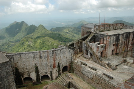
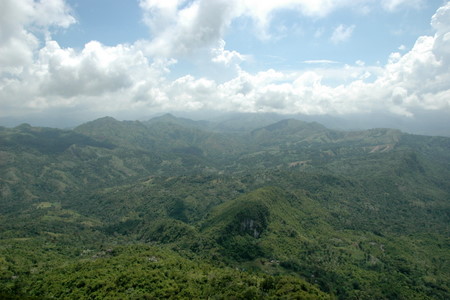
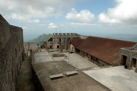
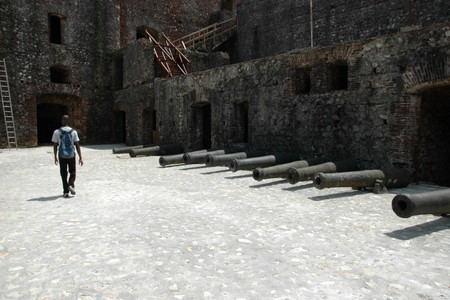
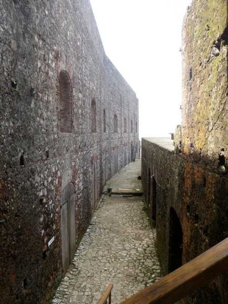
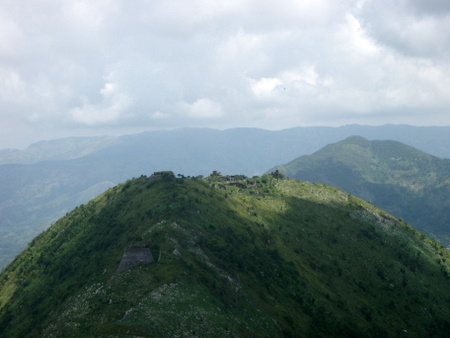
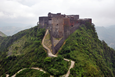
 The Citadelle Laferrière is a large mountaintop fortress in northern Haiti, approximately 17 miles /27 km south of the city of Cap-Haïtien and 5 miles /8 km uphill from the town of Milot.
 10’000m2.
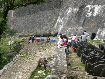
 The Citadel was part of a system of fortifications that included Fort Jacques and Fort Alexandre, built on the mountains overlooking Port-au-Prince. Dessalines ordered those forts built in 1805 to protect the new nation against French attacks.
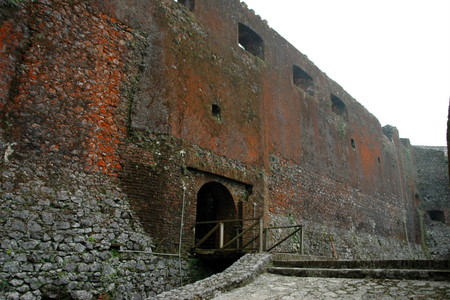
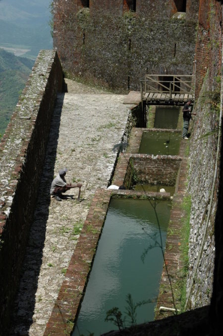
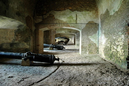
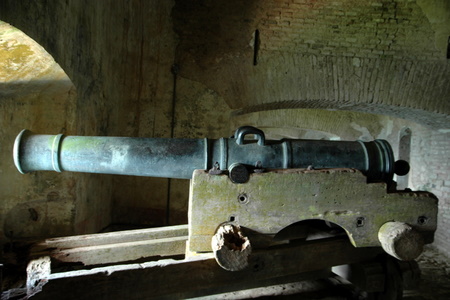
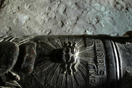
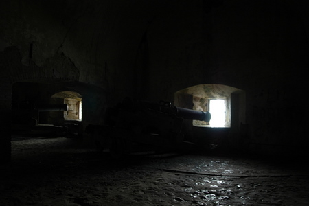
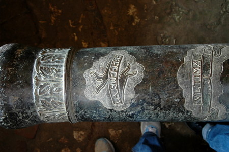
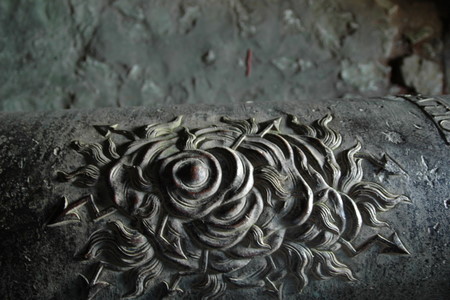
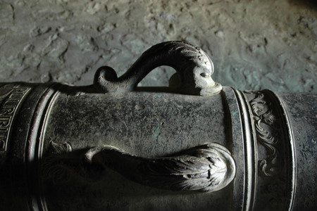
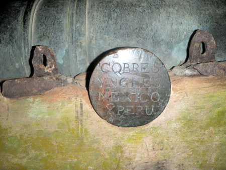
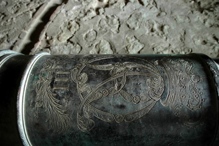 The fort was planned for 142 heavy bronze cannons, 124 heavy ordnance in casemates, 18 cannons mounted on „
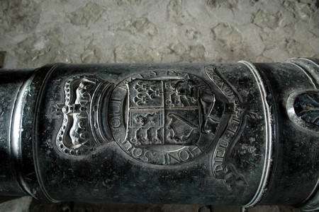
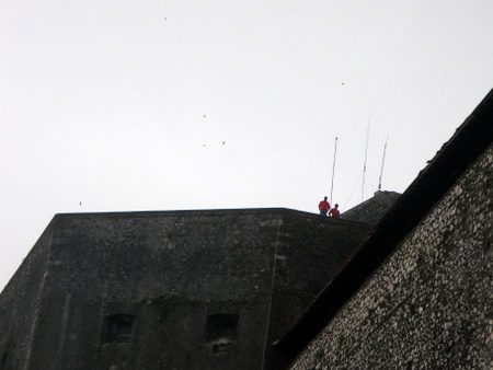
 The distinctive 43m high- cusp was placed at the head of the fortress- and named Batterie Coidavid -after Roi Christophe’s wife’s maiden name.
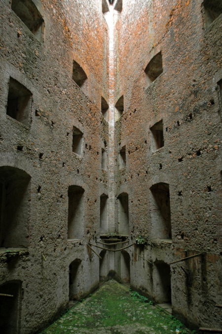
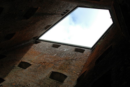
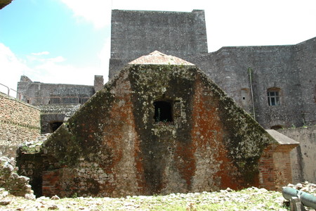 The Poudrière exploded in 1818, killing Prince Noël, the kings son-in-law and Citadel’s commander….
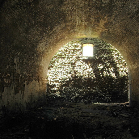 …who was smoking a cigarette nearby. Smell of gunpowder is stil in the air to this dayAfter an earthquake brought great damage to the fortress in 1842, it was abandoned and covered graudually with vegetation – until restoration works took place 1979-1990.
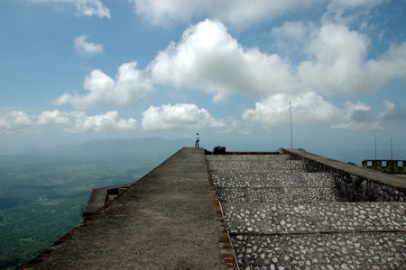
 Roi Christophe had been a builder and a very active king. After a stroke he suffered during mass in church St. Anne(?), his physical and mental capacities were impaired. When the palace guards mutinied against him, he shot himself with a silver bullet in the throne room of the Palace Sans-Souci.
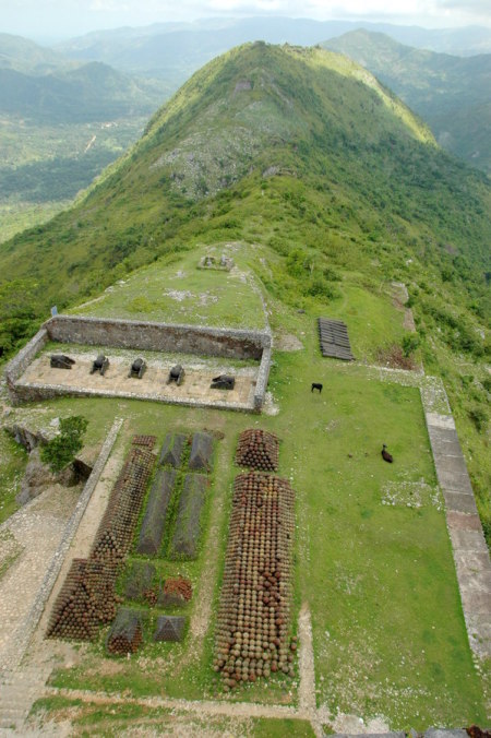

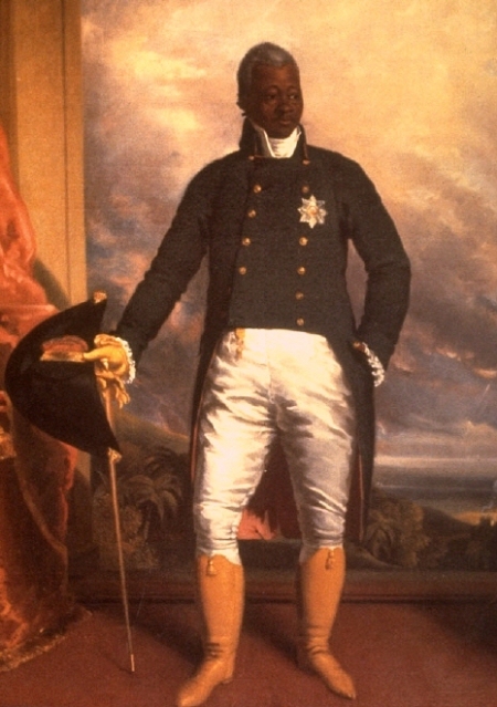 Roi Henry Christophe I

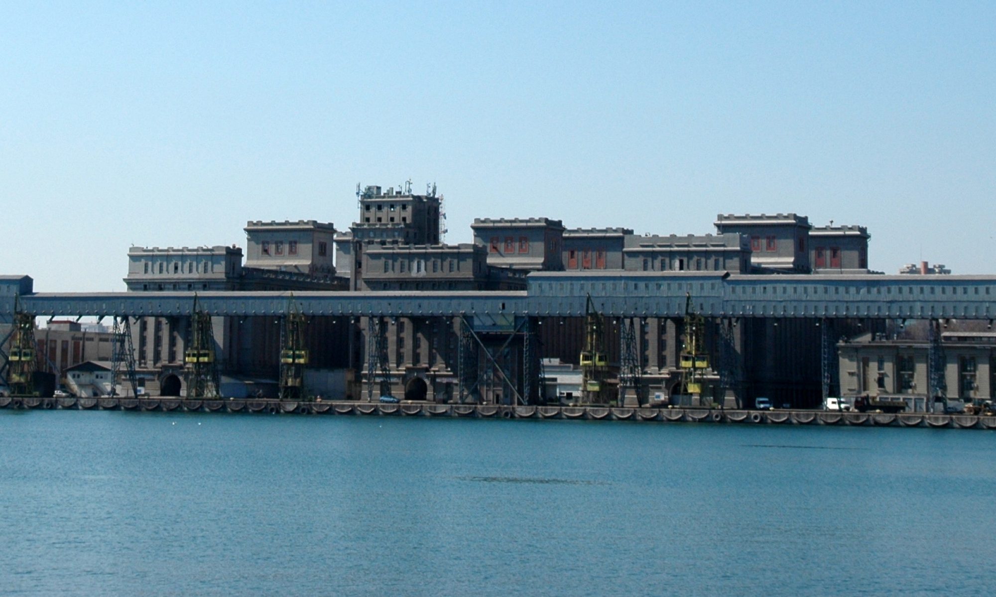
 ©www.ile-a-vache.com/
 Cement-packers in Les Cayes
 Cement transport from Port-au-Prince
 Bay in front of the hotelMorgan planned and staged many of his largest raids from Isla Vaca and in 1676 he narrowly survived a costly shipwreck on its shore: Morgan’s ship Jamaica Merchant sank with a full complement of cannon which the pirate had been bringing to bolster his presence at Port Royal.
 …and the bay behind the hotel
 Cabrit-conversation


 The restaurant at Fort Morgan

 Harbour-life


 Odd structure – church? hangar?
  When it rains, it pours
 Miragoane lake
 Boats take you over to the other side, the road passes under the water
 Back in Petit Goave, take a left for the office
 Ecole de Sacre Coeur, Petit Goave. On the left there was a religious monument people would pilger to; it collapsed during last years’ earthquake.
 Temporary school buildings provided by Cesvi, Italy
 Why do they always take pictures of the girls only?
  Curious and welcoming the white stanger. Is band aid provided only in white skin colour?
 But then there’s always something more interesting coming up
 Although one should always doubt these strangers…especially when they arrive in large groups, in white cars, with camera people and lots of foreign language talk.
 Like the press guys, focusing on the days’ event
 One day you’ll break someone’s heart
 Not mine, I’m going to discover the world!
 Class is being held in rooms with only 3 walls. More light and air than in normal classrooms
 Soccer game in a school yard, Port au Prince. By the noise, I thought the votes were out again!
 The old school building from 1901, Petit Goave


 Three star, aged four years
 Thursday night with RAM


 January 2011. Posters of the presidential candidates, aligned in front of the palace
 Jean Jacques Dessalines’ statue, Chinese humanitarian aid
 Champ de Mars Avenue. On the right, palace grounds. On the left, IDP-campIn spite of the image that is broadcasted by an indefatigable media in its craving for sensation, people here never lost their smiles.
 Higher playground


 The oldest game in the world
